Logistics services / Drone services
Drones in Logistics - Surveys, Inspections, Inventory & Facility Security
A drone in logistics is a precision analytical tool: it shortens investment timelines, controls inventory without halting operations and strengthens facility security. Vologis uses drones exclusively in logistics applications - from site surveys and photogrammetry, through autonomous inventory scanning in high-bay warehouses, AI-powered facility inspections with thermal imaging, to autonomous Drone-in-a-Box patrols. We integrate data directly into logistics projects.
- Geodetic surveys and orthophotomaps of investment sites
- Photogrammetry, 3D models and volume measurements
- Drone inventory scanning (RFID/LiDAR) without halting operations
- Hall roof and PV installation inspections with thermal imaging and AI
- Aerial Greenfield investment progress monitoring
- Facility patrol and security - Drone-in-a-Box
Three problems a drone solves faster and cheaper than traditional methods
A traditional geodetic survey of a large investment site takes days and engages a multi-person field team. A drone surveys the same site in hours - with centimetre accuracy - and the orthophotomap and 3D model go straight to the layout designers and investment analysts.
In high-bay warehouses, manual inventory takes days of downtime and errors reaching several percent. Drones with RFID and LiDAR autonomously scan racking at night, without halting operations - delivering an accurate picture of stock ready by morning.
Patrolling a facility by traditional means has blind spots and depends on security availability. Drone-in-a-Box launches automatically on zone breach and immediately streams footage to the security centre. This Loss Prevention complement works round the clock without an extra headcount.
6 drone applications in logistics
Exclusively logistics applications - from site surveys for investment through autonomous inventory to completed facility security.
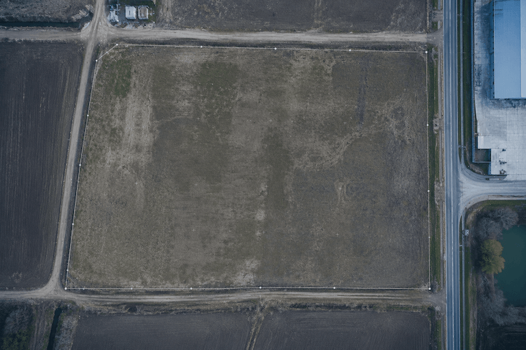
Geodetic surveys and orthophotomaps
Precise surveys of investment sites and logistics land - accurate to centimetres. Orthophotomaps provide a true-scale aerial view of the site, ready for layout design, accessibility analysis and investment documentation.
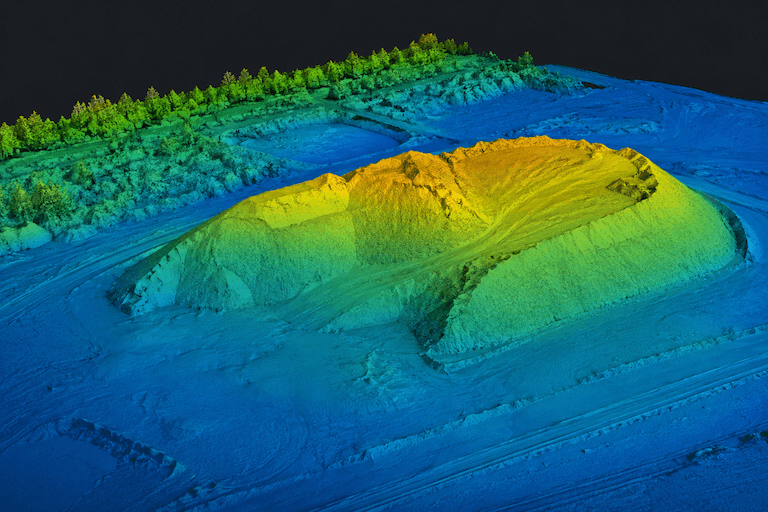
3D models, photogrammetry and volume measurements
Digital twins of land and logistics facilities: 3D models created from drone imagery (photogrammetry). Precise volume measurement of bulk materials and stockpiles - quantity control without manual field measurement. Data supports Greenfield projects from the planning stage.
See Greenfield projects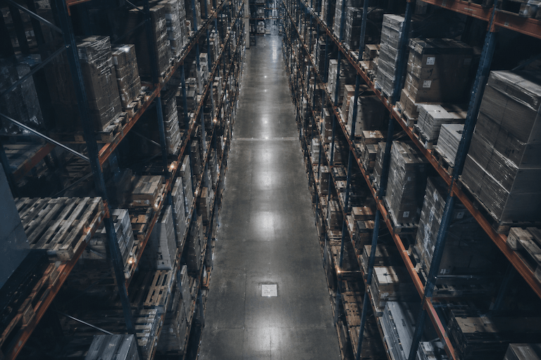
Warehouse inventory scanning
Drones equipped with barcode readers, RFID and LiDAR scanners autonomously count and locate pallets between high-bay racking - even at night, without halting operations. They eliminate manual counting errors and free up staff from tedious inventory tasks.
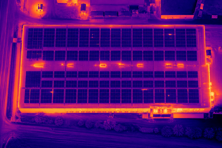
Logistics facility inspections
Inspections of warehouse hall roofs, photovoltaic installations and facility technical condition. Thermal cameras and AI algorithms detect micro-damage, insulation defects and PV failures before they become costly repairs or operational disruptions.
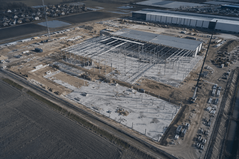
Construction progress monitoring
Regular aerial documentation of construction progress - from first groundwork to facility handover. Objective, date-stamped record for the investor, independent of contractor reports. Integrated with Vologis Greenfield project management.
See Greenfield projects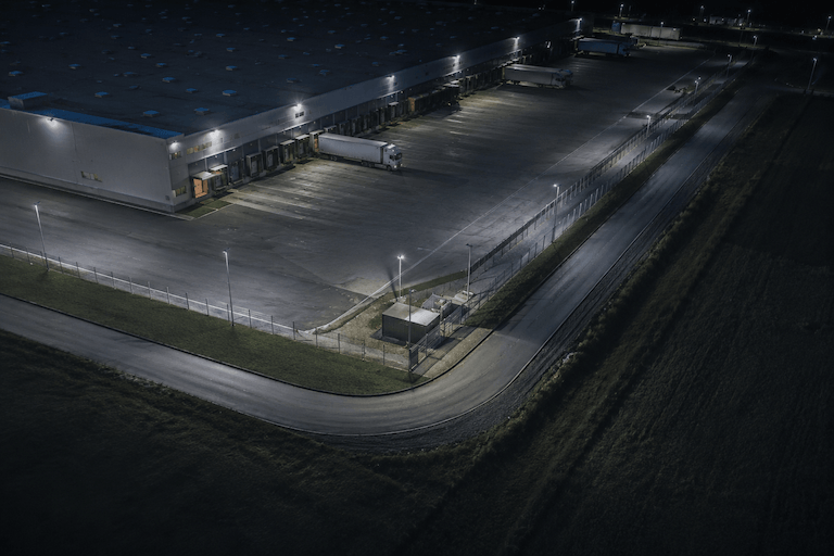
Facility patrol and security - Drone-in-a-Box
Autonomous patrols around logistics centres and warehouses. The drone launches automatically on zone breach detection, streaming live video to the security centre. A Loss Prevention complement that operates 24/7 without extra headcount.
Operational security and Loss PreventionWho are drone services for?
We work wherever precise aerial data has a real impact on investment and operational decisions.
Logistics facility developers and owners
When you need site surveys, construction monitoring, technical condition inspections and completed facility documentation.
Investors and funds
When you want to objectively assess an investment plot or independently track Greenfield project progress.
Warehouse operators and 3PLs
When you need drone inventory scanning in a high-bay warehouse, a hall roof inspection or autonomous facility patrol.
Companies executing Greenfield projects
When drones are to be an integral part of the investment process - from geodetic surveys to construction monitoring and completed facility security.
Companies responsible for facility security
When you're looking for a technology complement to a security and Loss Prevention system - autonomous patrol as part of round-the-clock surveillance.
Unique integration
What sets us apart from a typical drone company
A drone company delivers photos. We deliver data in the context of your logistics project. We know what an orthophotomap means for a warehouse layout, how drone inventory translates into operational continuity and how Drone-in-a-Box integrates with a facility security system.
Drone services here are part of a larger whole - logistics consulting, Greenfield projects and operational security. Data from the drone goes directly into the decision-making process, not into a folder of files.
See how we manage Greenfield projectsFAQ - frequently asked questions
Can drones inventory stock without halting warehouse operations?
Yes. Drones equipped with RFID readers, barcode scanners and LiDAR conduct autonomous inventory scanning between high-bay racking - often at night or in sections outside active operation, without stopping forklifts or evacuating personnel.
How accurate are geodetic drone surveys?
With appropriate procedures and reference points we achieve accuracy to a few centimetres. The specific accuracy level is agreed depending on the measurement purpose and project requirements.
How does thermal inspection differ from a standard roof inspection?
A thermal camera on a drone detects leaks, insulation defects and PV thermal anomalies that are invisible to the naked eye during a standard inspection. AI algorithms automatically locate and classify anomalies - shortening analysis time and documenting facility condition in a format ready for engineering review.
How does Drone-in-a-Box work?
Drone-in-a-Box is an autonomous docking station with a drone that launches automatically on zone breach detection by the alarm system or on operator request. The drone streams video to the security centre in real time and returns automatically to the station after completing the patrol. It supplements the CCTV system and physical security.
Is construction monitoring a one-off or recurring service?
Most often recurring - regular flights at set intervals provide an objective picture of construction progress over time. A single measurement or documentation at a specific project stage is also possible.
Need aerial data for a logistics project?
Site survey, inventory scanning, roof inspection, construction monitoring or facility patrol - tell us what you need and we'll select the right application.
Detailed solutions
Detailed pages for each drone application in logistics and investments.
Drone-in-a-Box as part of Loss Prevention
Autonomous drone patrol is a tool within the operational security system of a logistics facility. We integrate Drone-in-a-Box with Loss Prevention processes, access control and CCTV monitoring.
Operational security and Loss Prevention